
File:Tanzania map-en.svg

Size of this PNG preview of this SVG file: 596 × 599 pixels. Other resolutions: 239 × 240 pixels | 477 × 480 pixels | 764 × 768 pixels | 1,019 × 1,024 pixels | 2,037 × 2,048 pixels | 2,064 × 2,075 pixels.
Original file (SVG file, nominally 2,064 × 2,075 pixels, file size: 3.15 MB)
Captions
Captions
Add a one-line explanation of what this file represents
| Description |
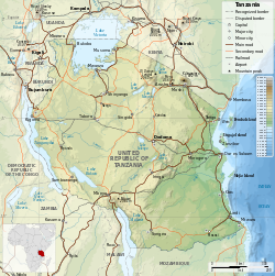
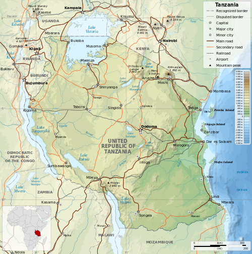
English: Map of Tanzania in English. Equirectangular projection. 1° N, 28° W, 42° E, -13° S. |
||
| Date | |||
| Source | |||
| Author |
|
||
| Permission (Reusing this file) |
I, the copyright holder of this work, hereby publish it under the following licenses:
This file is licensed under the Creative Commons Attribution-Share Alike 4.0 International, 3.0 Unported, 2.5 Generic, 2.0 Generic and 1.0 Generic license.
You may select the license of your choice. |
||
| Other versions |
[]
|


This image has been assessed using the Quality image guidelines and is considered a Quality image.
|
File history
Click on a date/time to view the file as it appeared at that time.
| Date/Time | Thumbnail | Dimensions | User | Comment | |
|---|---|---|---|---|---|
| current | 18:06, 8 July 2014 | | 2,064 × 2,075 (3.15 MB) | Calliopejen1 (talk | contribs) | fix typos |
| 17:48, 8 July 2014 |  | 2,064 × 2,075 (3.15 MB) | Calliopejen1 (talk | contribs) | {{Information |Description={{en|1=Map of Tanzania in English. Equirectangular projection. 1° N, 28° W, 42° E, -13° S.}} |Source=*Tanzania_map-fr.svg |Date={{date|2014|7|8}} |Author=*[[:File:Tanzania_m... |
You cannot overwrite this file.
File usage on Commons
The following 52 pages use this file:
- User talk:Sémhur
- Commons:Quality images/Subject/Non photographic media
- Commons:Quality images/Subject/Non photographic media/Sample
- Commons:Quality images candidates
- Commons:Quality images candidates/Archives April 28 2026
- Commons:Quality images candidates/ar
- Commons:Quality images candidates/ca
- Commons:Quality images candidates/cs
- Commons:Quality images candidates/cy
- Commons:Quality images candidates/da
- Commons:Quality images candidates/de
- Commons:Quality images candidates/en
- Commons:Quality images candidates/en-ca
- Commons:Quality images candidates/es
- Commons:Quality images candidates/fa
- Commons:Quality images candidates/fr
- Commons:Quality images candidates/gl
- Commons:Quality images candidates/hi
- Commons:Quality images candidates/id
- Commons:Quality images candidates/it
- Commons:Quality images candidates/ja
- Commons:Quality images candidates/lv
- Commons:Quality images candidates/mai
- Commons:Quality images candidates/mk
- Commons:Quality images candidates/ms
- Commons:Quality images candidates/nl
- Commons:Quality images candidates/ny
- Commons:Quality images candidates/pl
- Commons:Quality images candidates/pt
- Commons:Quality images candidates/ru
- Commons:Quality images candidates/sq
- Commons:Quality images candidates/sv
- Commons:Quality images candidates/th
- Commons:Quality images candidates/tr
- Commons:Quality images candidates/uk
- Commons:Quality images candidates/zh
- File:Tansania map-de.svg
- File:Tanzania location map.svg
- File:Tanzania map-be.svg
- File:Tanzania map-bg.svg
- File:Tanzania map-en.svg
- File:Tanzania map-es.svg
- File:Tanzania map-fr.jpg
- File:Tanzania map-fr.svg
- File:Tanzania map-it.svg
- File:Tanzania map-mk.svg
- File:Tanzania map-nb.svg
- File:Tanzania map-ru.svg
- File:Tanzania map-sw.svg
- File:Tanzania map-uk.svg
- File:Tanzania relief location map.svg
- Template:Other versions/Maps of Tanzania
File usage on other wikis
The following other wikis use this file:
- Usage on bh.wikipedia.org
- Usage on bn.wikipedia.org
- Usage on ca.wikipedia.org
- Usage on en.wikipedia.org
- Usage on fi.wikipedia.org
- Usage on hu.wikipedia.org
- Usage on hu.wiktionary.org
- Usage on mdf.wikipedia.org
- Usage on ml.wikipedia.org
- Usage on mn.wikipedia.org
- Usage on sco.wikipedia.org
- Usage on si.wikipedia.org
- Usage on sl.wikipedia.org
- Usage on www.wikidata.org